Today’s entry in this series is brief but (I think) really cool.
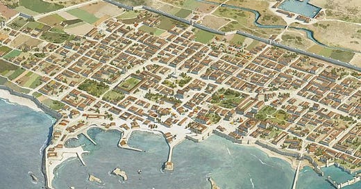
Here’s a screenshot of a drawn map of old Alexandria from a history magazine’s website:
…
Ancient History Magazine, that is, and Alexandria, Egypt, that is—as it’s thought to have looked a little over 2,000 years ago.
Somebody on Twitter shared this image, in response to a viral tweet I wrote:
His point was that what we think of as a traditional urban form isn’t just a small town in America, or an old European city (okay, maybe less of a grid there), but is basically a form that goes back across cultures and across millennia. Cities are things that we build almost naturally, like anthills.
I went on, in my tweet thread, to argue that the changes in land use and transportation in the 20th century basically amounted to a revolution in the fullest sense: a break with the past, and to a great extent a muddying or erasure of what the past even was.
You might think this argument is contradicted by the fact that we do have a lot of historic cities and towns in America, even after urban renewal. But I think that makes the point, and adds an element of irony: we live among these legacy cities, but we don’t really know why they exist, what they are, or what purpose they originally served.
Here, by the way, is Old Town Alexandria in Virginia:
Scroll back up and compare those two images. I’ll leave you with that.
Related Reading:
“Streets Closed to Vehicular Traffic”
Thank you for reading! Please consider upgrading to a paid subscription to help support this newsletter. You’ll get a weekly subscribers-only piece, plus full access to the archive: over 800 pieces and growing. And you’ll help ensure more like this!


